A portion of Montana State Primary Route 69 (MT 69) south of Boulder, in Jefferson County, was nominated for reconstruction, and a preliminary field review was conducted by the Montana Department of Transportation (MDT) in May 2004. MDT announced plans to reconstruct a portion of MT 69 in a press release in November 2004.
MDT began the process of identifying a consultant to conduct an analysis of the proposed project and its potential impacts in December 2004. MDT conducted a public scoping meeting held on June 1, 2005 in Boulder. The southern (Mile Post [MP] 22.3 to MP 31.8±) and northern (MP 31.8± to MP 37.5±) portions of the proposed project, and two alignment alternatives for the northern portion were presented at the public meeting. One alignment option involved reconstruction of the existing MT 69 alignment, and one involved construction of a new alignment on the east side of the Boulder River following an existing Jefferson County road as much as practicable. Approximately 100 people attended the meeting and the majority of those in attendance expressed their disapproval of any new alignment east of the river.
During the public meeting, public participants expressed concern about potential impacts to the rural character of the existing MT 69 corridor. Meeting attendees were also concerned about potential impacts to the Boulder River, wildlife habitat adjacent to MT 69, agricultural operations, and the aesthetic quality of the corridor. While some attendees expressed a desire for better travel conditions for vehicles, the majority of public participants did not want to create a roadway that would encourage higher speeds and traffic volumes, or that would require substantial amounts of new right-of-way.
Many residents who own property on the east side noted that they would not be willing sellers of any needed right-of-way for a new alignment. State Representative Scott Mendenhall expressed his concern that the state would have a difficult time justifying the acquisition of property on the east side of the river if it would be at all feasible to reconstruct the existing MT 69 alignment, as noted in the transcript for the June 2005 public meeting. Through later correspondence, the Jefferson County Commission and Planning Board separately expressed their concern over a new alignment and favored reconstruction along the existing MT 69 alignment in letters dated July 6 and July 14, 2005, respectively. The County initially considered taking responsibility for maintenance of the existing roadway if a new roadway were constructed, but later determined they would not be willing to assume this maintenance responsibility, as noted in a letter dated September 22, 2006.
Given the intense level of public opposition and the admonitions from state and local elected officials, MDT decided to conduct a preliminary screening of alternatives to compare the relative pros and cons of the two alternatives initially under consideration.
Alternatives Analysis
An Alternatives Analysis was completed in December 2009. This report documents the early alternatives screening process used in the MT 69 corridor with the intent of fulfilling future NEPA/MEPA requirements. The report identifies the primary factors for project nomination in the corridor, documents the rationale and history behind the development of alternatives, defines a set of screening criteria based on NEPA/MEPA requirements, and presents a planning-level evaluation of alternatives under consideration in the corridor.
Based on the results of the screening process, this study has identified rehabilitation / reconstruction and widening of the existing alignment as the only reasonable and practicable alternative that would address the Purpose and Need in the Boulder corridor. While social and environmental impacts would be expected with this alternative, practicable avoidance, minimization and mitigation measures would be incorporated as the design process evolves.
Accordingly, this study recommends elimination of the No Build, Spot Improvements, Eastern Alignment, and Western Alignment alternatives from further consideration.
Environmental Assessment
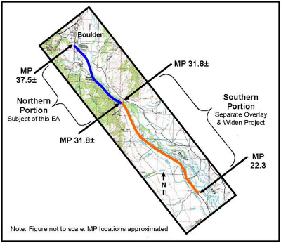
Since project initiation, the original project was split into two projects due to the corridor's two distinct types of topography. The southern portion (MP 22.3 to MP 31.8±) is up on a bench away from the Boulder River and primarily traverses pastureland. This portion of the roadway was defined as an independent overlay and widening project, which is being completed under a categorical exclusion, approved on May 10, 2007. The northern portion (MP 31.8± to MP 37.5±) travels down along the Boulder River bottom, with areas of wetlands on both sides of the roadway and a greater potential for impacts to natural resources as compared to the southern portion. The roadway also runs past a steep rock cut and areas of close proximity to the Boulder River. The northern portion is the focus of this Environmental Assessment (EA).