
Welcome to MDT’s Interactive web maps!
Let’s get to know your traffic.
Please note: If you are working on or contracted to do an MDT project, do not use data from these maps – continue
Statewide Traffic Web Map
If you are looking for current Annual Average Daily Traffic (AADT), click on the map below.
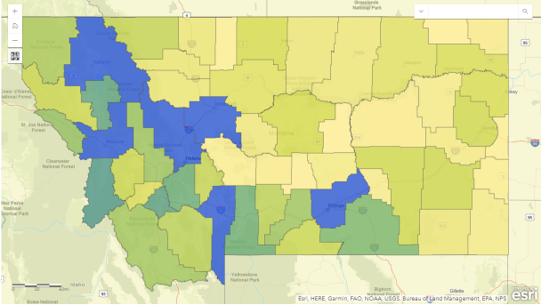
Information layers displayed in this map include:
- County Daily Vehicle Miles Traveled (DVMT)
- Traffic Counts
- Traffic Segments
Additional Info: Read more about the attributes found in the traffic map.
MS2 Traffic Map
For more detailed traffic information, click on the map below.
This is MDT’s cloud-based, public facing, traffic count database system.
Additional Info: Learn how to navigate TCDS.
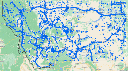
Traffic Continuous Count Stations Viewer
For more information about CCS sites, click on the map below.

This map only displays the Continuous Count Stations (CSS). For their locational details, click on any of the features in the map. To view traffic data for the CCS sites, please go to the statewide traffic map or to MDT’s public facing traffic count database system map above.
Additional Info:
MS2 Dashboard
Click on the map below to show daily traffic trends.
The data in the dashboard is based on MDT’s 105 active Continuous Count Station (CCS) sites only.
Additional Info:
- Visit our traffic count database system (TCDS) for more detailed traffic data. *Map seen above.
- Learn how to navigate TCDS
Disclaimer: This data set is provided "as-is" without warranty of any kind. The Montana Department of Transportation makes no representations or warranties whatsoever with respect to the accuracy or completeness of this data set and assumes no responsibility for the suitability of this data set for a particular purpose; and MDT will not be liable for any damages incurred as a result of errors in this data set.