Project Overview
The Montana Department of Transportation (MDT) is proactively investing in safe, pedestrian-friendly infrastructure to reach its Vision Zero goal. The River's Edge Trail Connector Project will enhance safety for users of the River's Edge Trail system in Great Falls by constructing an alternate route between Central Avenue West and Broadwater Bay.
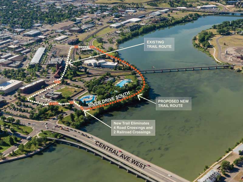
The current route of the River’s Edge Trail leaves the river’s edge just south of Central Ave West. It crosses four busy streets and two active rail lines as it winds its way around a corporate office building, past the old Great Northern Railroad depot, and through the parking lot of the Great Falls Police Department before returning to the river at Broadwater Bay. This project will construct a new “connector” trail that will hug the Missouri River. This will enhance safety for trail users, as the proposed trail alignment along the river eliminates the street and railway crossings.
MDT is partnering with the City of Great Falls, the River's Edge Trail Foundation, and TD&H Engineering to accomplish this important project.
Project Location

Proposed route of the River’s Edge Trail Connector. Image courtesy of LPW Architecture.
Click the image for a larger view
The River’s Edge Trail Connector Project is located in Great Falls, just east of the Missouri River, between Central Avenue West and 3rd Avenue South. Here is the proposed route of the new connector trail:
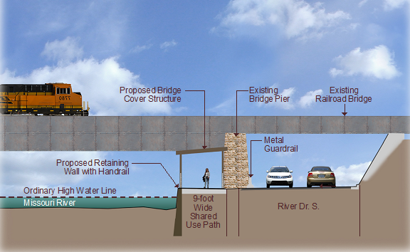
Immediately south of Central Avenue West, the new segment will branch off the existing River’s Edge Trail. The path will head south through the park area between the river and River Drive South, then hug the riverbank until it reaches the railroad bridge. The construction of a retaining wall will permit the path to pass under the railroad bridge, between the road and the river. After the railroad bridge, the path will follow the edge of River Drive South until it reaches Broadwater Bay. At Broadwater Bay, it will pass through the open park area, cross the north entrance to the boat ramp, then reconnect to the Rivers Edge Trail near the intersection of River Drive South and 3rd Avenue South.
Project Design
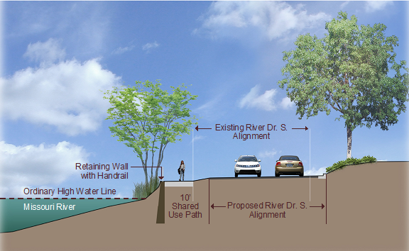
This project will construct a new section of shared-use path. Most of the proposed path will be 10 feet wide with a 5-inch-thick concrete surface. Under the railroad bridge, a retaining wall will be constructed along the river to support a slightly narrower (9 feet wide) path. South of the railroad bridge, a portion of River Drive South will be realigned to reduce impacts to the riverbank from construction of the new path.


As part of the project, the existing pedestrian crossings of River Drive South at the north end of Electric City Water Park and at the intersection with 3rd Avenue South will be upgraded with Rectangular Rapid Flashing Beacons (RRFB) like those recently installed on River Drive North.
During the preliminary design process, MDT explored a variety of design options. A retaining wall with a road realignment was selected due to reduced environmental impacts, decreased geotechnical engineering concerns, and lower project costs.
Public Involvement
MDT is seeking public comment on this project while it is in the design phase. Those wishing to comment on the project should contact Ella Currier at
