
Using targeted remote sensing and other advanced survey techniques, combined with data-driven analysis, this pilot study will evaluate how well these approaches can identify meaningful changes in slope conditions and determine whether rockfall material reaches the roadway or is effectively contained (e.g., within ditches). The results will help Montana Department of Transportation (MDT) improve the consistency of slope evaluation and prioritization of mitigation efforts, supporting more efficient use of maintenance resources, improved safety, and reduced traffic disruptions. The study will also provide insight into how repeated observations can be used to track changes in slope condition and performance over time, supporting long-term planning and asset management.
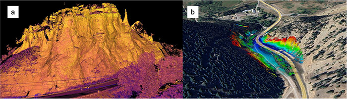
High-resolution terrestrial LiDAR products for the Bridger Canyon corridor along MT-86. (a) Three-dimensional point cloud of cliff walls acquired using terrestrial laser scanning. (b) Distance-based contour map derived from LiDAR returns, where color gradients represent relative distance from the scanner and highlight variations in slope geometry along the canyon walls.
For more information, please send an email to