
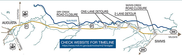
Location Map
Click to view a larger image.
Locations (by mileposts)
- (Elk Creek), 0.2 (Elk Creek Overflow), and 0.7 (Hogan Slough): Due to recent flood events, the work type and schedules for these bridges are being re-evaluated.
- 18.7 (Fort Shaw Canal): minor deck widening and guardrail upgrades
- 9.2 (Dry Creek), 17.9 (Heppler Coulee), and 19.8 (Simms Creek): new wider bridge decks and guardrail upgrades
- 12.0, 14.5 & 17.4: replace bridges with culverts
- 4.25: Lengthen irrigation culvert