
About the Program
Montana Department of Transportation (MDT) projects sometimes result in unavoidable impacts to wetlands and other aquatic habitats. This requires MDT to provide compensatory mitigation to these aquatic resources in compliance with Federal, State and Tribal regulations. In many cases these impacts must be mitigated at a minimum acreage ratio of an acre for an acre to replace these aquatic resources. MDT in its mitigation efforts, attempts to replace these aquatic resources with wetland and stream mitigation projects that replace wetland habitat types and those functions and values impacted by transportation projects within the watershed.
What is a watershed? It’s the land area that drains water to a particular such as a stream, lake, estuary, wetland, aquifer, or even the ocean. It is a land feature that can be identified by tracing a line along the highest elevations between two areas on a map, often a ridge. For the purposes of aquatic resource mitigation, the Federal, State and Tribal natural resource and permitting agencies have agreed to breakdown the state into an area consisting of 16 major watersheds. One of these large watersheds can be further divided into hundreds of smaller watersheds.
What is a wetland? Wetlands are areas where water covers the soil, or is present either at or near the surface of the soil all year or for varying periods of time during the year, including during the growing season. Water is the dominant factor determining the nature of soil development and the types of plant and animal communities living in the soil and on its surface at these locations. In Montana, a variety of wetland habitat types exist including: prairie and glacial potholes; saline basins and alkali flats; riparian scrub/shrub wetlands; sloughs and abandoned meanders along rivers; spring seeps and hot springs; emergent fringe wetlands around lakes, ponds, and reservoirs; fens, wet meadows; and artificial man-made wetlands.
Wetland Mitigation Sites
Select a site on the map or use list below.
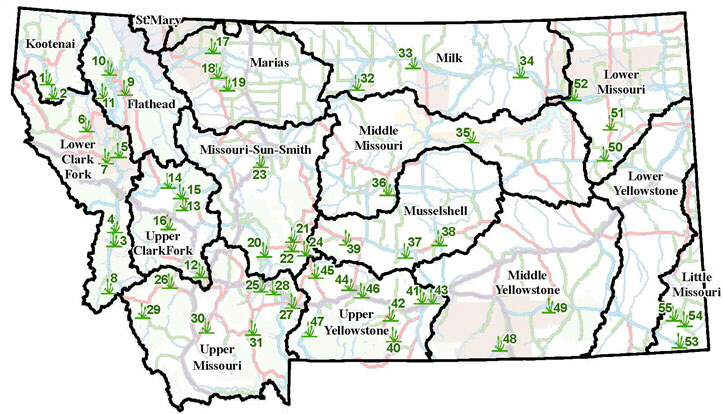
Kootenai - 1
Upper Clark Fork - 2
Lower Clark Fork - 3
Flathead - 4
St. Mary - 5
None
Upper Missouri - 6
Missouri-Sun-Smith - 7
Marias - 8
Middle Missouri - 9
Musselshell - 10
Lower Missouri - 12
Upper Yellowstone - 13
Middle Yellowstone - 14
Lower Yellowstone - 15
None