
What are land use regulations?
Regulatory tools for land development and design can be used to provide an alternative to the typical disconnected, auto-dependent developments that have commonly been built in the United States since the 1950's. Zoning codes, subdivision ordinances, parking ordinances and other regulatory mechanisms can be used to shorten distances between work, home, shopping, and recreational areas to promote walking and bicycling, and have the potential to increase transit ridership and reduce vehicle miles traveled.
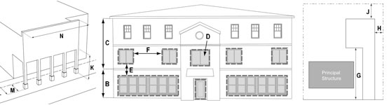
Zoning codes have traditionally been used to separate incompatible land uses, such as industrial sites and residential areas. An unforeseen consequence of this separation, however, is that broad distances between homes, jobs, and commercial centers require residents to use automobiles for virtually every trip and preclude the use of other modes such as transit, walking and bicycling. In addition, some communities are concerned that isolated subdivisions, office parks, and shopping centers do not generate the sense of place desired by many local residents. As a result, there has been a trend toward crafting or updating zoning codes that regulate the form of development more than the types of land uses.
Two of the more popular tools are the Form-Based Code and Smart Code. Both the Form-Based Code and Smart Code establish zones of building types based on pedestrian accessibility and the scale and character of surrounding development. The development of zoning codes that focus on urban form can be used as a tool to encourage collaboration among local governments and public and private stakeholders to identify and implement principles that reflect local goals for quality of life.
Subdivision ordinances explain the regulatory process for dividing a parcel of land into separate independent sub-parcels. In Montana, subdivision regulations are required for all cities, counties, and towns. Local governments may use the subdivision ordinance to promote efficient land use strategies, such as cluster development and preservation of open space.
Development Permits (also called Performance Standards, Development Standards, or Permit Systems), are sometimes used as an alternative to zoning. They focus on physical elements of development (e.g., building standards and minimum lot sizes) more than land use types.
The design and location of parking space has a significant influence on community design. Traditional parking ordinances are usually based upon suburban-scale, automobile-oriented standards and can conflict with the preservation and development of multimodal urban and suburban places. Innovative parking ordinances that support compact, pedestrian-oriented development include maximum parking limits (e.g., Portland, OR), reducing minimum parking requirements in areas served by multimodal infrastructure (Pasadena, CA), and allowing shared parking for mixed land uses (e.g., Montgomery County, MD).
Who can implement it?
Zoning regulations in cities and towns, authorized (but not required) under the Municipal Zoning Act (Title 76 Chapter 2 part 3 MCA), are overseen by a Zoning Commission, and approved by the local Council. Municipalities can propose extending their zoning outside city or town boundaries. County ordinances, authorized under the County Zoning Act (Title 76, Chapter 2, part 2, MCA), are overseen by a Planning Board and approved by the County Commission.
Planning and Zoning Districts for specific geographic areas can be created within a portion of a county through a landowner-initiated petition to the County Commission, which approves the district regulations after a public hearing. A planning and zoning commission for the district is appointed by the County Commission, as authorized by the County Zoning Act (Title 76, Chapter 2, Part 1, MCA). At least 60 percent of landowners within the District must sign a petition.
Subdivision Regulations are required for all cities, counties, and towns according to the Montana Subdivision and Platting Act (Title 76, Chapter 3 MCA). The most commonly applied planning and regulatory tool in the state, they regulate the division of land into lots of less than 160 acres that must comply with local growth policies and design standards, thus considering impacts to the natural environment, agricultural and water facilities, public health, safety, and local services. Local governments may use the subdivision ordinance to promote cluster development and preservation of open space.
Landowners who propose a major subdivision of six or more lots must provide an environmental impact assessment as well as land or monies for public parks, and the local government must conduct public hearings and document their approval process. Land divided among family members usually qualifies for Family Transfer Exemptions, and is not subject to subdivision requirements.
What are the keys to success and potential pitfalls?
All regulatory requirements must be made in accordance with the growth policy or a master plan, and must consider the character and value of the district where it is to be applied.
The advantage of using Planning and Zoning Districts as a mechanism for regulating land use is that landowners are committed to the plan, having usually drawn it up themselves, and it is easier to adopt policies for a small area rather than county-wide. However, the district plan may not be particularly consistent with county-wide or regional plans or policies regarding travel demand and environmental protection.
Like zoning, development permits can be set by cities, towns, counties, and county districts designated through landowner petitions. Two of the State's 12 fastest growing counties rely on permitting as their primary tool. Authorized by the Zoning Act (Title 76, Chapter 2, Part 1 (county) and 3 (city), permitting requires well-written documents and a strong development review process in order to be effective
Where has this strategy been applied?
Examples in Montana
- City of Missoula Subdivision Guide and Toolbox
The City of Missoula has assembled an online guide to information and tools to assist with the City's subdivision approval process and provide links to documents from its Public Works Department. The information available from the web site provides developers with information needed for each stage of the subdivision review and approval process and provides links to interactive GIS mapping from the City, city engineering design criteria and standard drawings, as built drawings of existing infrastructure, and links to other city and state guidance and regulatory documents. The web site provides convenient and centralized location for the information most often needed for subdivision proposals - The Montana Department of Commerce's Community Technical Assistance Program (CTAP) has taken the lead in helping to develop model subdivision regulations for the State of Montana that can be used as an example and reference for local governments preparing or revising their own regulations. The agency periodically produces the Montana Model Subdivision Regulations, an advisory publication that reflects regulatory changes needed as a result of revisions to the Montana Subdivision and Platting Act made during legislative sessions.
Examples outside of Montana
- Model Smart Growth Zoning Codes
The Growth Alternatives Alliance is a unique partnership of local governments, the building industry, business alliances, farming organizations, and nonprofit groups in California's San Joaquin Valley. Together with the Local Government Commission, the Growth Alternative Alliance developed a set of model Smart Growth Zoning Codes and introduced numerous San Joaquin Valley communities to these codes. Jurisdictions are taking action to incorporate the principles of these codes into their own plans and regulations - Model Transit-Oriented Development Zoning Overlay District
The Columbus, Ohio MPO, the Mid-Ohio Regional Planning Commission (MORPC), developed a zoning overlay district ordinance for local jurisdictions. The model ordinance is intended as a starting point that communities can modify to reflect local priorities. The model ordinance identifies permitted and restricted uses, minimum and maximum densities, parking requirements, and standards for building placement, design, and orientation.
Case studies
How can I get started?
Prior to adopting any regulatory mechanism, it is important to have established a vision for the community either by adopting a growth policy or master plan that has been vetted through the public process.